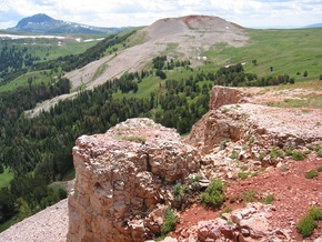
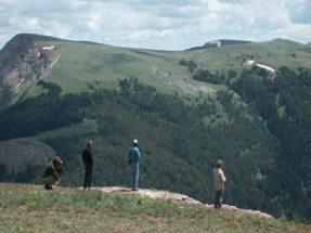
Madison Valley Project:
|
Here is a short video that explains our Conservation Planning approach with some footage from the Madison Valley.
http://videos.sorensonmedia.com/Denver+Film+%26+Digital+/Craighead+Institute/02375ba3n010aN439dO8b1eo5eda62bdb625
http://videos.sorensonmedia.com/Denver+Film+%26+Digital+/Craighead+Institute/02375ba3n010aN439dO8b1eo5eda62bdb625
Craighead Institute - Building Tools for Effective Stewardship
click on photo to view video
Project Goals
The Craighead Institute began conservation planning in the Madison Valley in 2001 and completed a broad-scale analysis in 2004. In 2005 and 2006, the Craighead Institute collaborated with the Wildlife Conservation Society (WCS) to identify local conservation needs and set priorities, an effort that resulted in the detailed Madison Valley Wildlife Conservation Assessment (Brock et. al. 2006). This assessment has already proven valuable to developers and county officials in the county subdivision review process, helping them guide projects in ways that retain important wildlife areas.
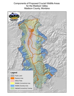
The Institute has also worked with Madison County planners, state and federal agencies, and community members to develop a wildlife conservation overlay district. In June 2008, maps for the district were completed, identifying the most important areas that may warrant special mitigation to protect wildlife and habitat. Guidelines for protecting these important areas were drafted in 2010.
- To foster a more complete understanding of the relationship
between development and wildlife
- To create a conservation planning framework and process that guides development in ways that reduce wildlife-human conflicts
- To establish effective tools that can be applied throughout the Northern Rockies and elsewhere to help communities better preserve their wildlife and wild landscapes
- To maintain and enhance core habitats and landscape connectivity for large carnivores and other vital wildlife species
- To ensure that wild animals will continue to be able to move across this landscape to meet daily, seasonal, and lifetime needs and adapt to the changing climate
The Craighead Institute began conservation planning in the Madison Valley in 2001 and completed a broad-scale analysis in 2004. In 2005 and 2006, the Craighead Institute collaborated with the Wildlife Conservation Society (WCS) to identify local conservation needs and set priorities, an effort that resulted in the detailed Madison Valley Wildlife Conservation Assessment (Brock et. al. 2006). This assessment has already proven valuable to developers and county officials in the county subdivision review process, helping them guide projects in ways that retain important wildlife areas.
The Institute has also worked with Madison County planners, state and federal agencies, and community members to develop a wildlife conservation overlay district. In June 2008, maps for the district were completed, identifying the most important areas that may warrant special mitigation to protect wildlife and habitat. Guidelines for protecting these important areas were drafted in 2010.
City and County Planning
The Institute has also worked with Madison County planners, state and federal agencies, and community members to develop a wildlife conservation overlay district. In June 2008, maps for the district were completed, identifying the most important areas that may warrant special mitigation to protect wildlife and habitat. Guidelines for protecting these important areas were drafted in 2010. They have been incorporated into draft subdivision regulations both for the county and as recommendations by Montana Fish, Wildlife, and Parks, although they have not yet been enacted.
Computer-Based Tools for Conservation Planning
Computer-based tools designed by the Craighead Institute are intended to guide development in a way that recognizes and accommodates the needs of wildlife to live and roam. The tools can help participants in the development process answer questions about potential impacts on wildlife early in project planning, when changes to reduce or eliminate problems are easier and less expensive. The tools also allow planners and developers to explore variations in building and road placement that could mitigate impacts on wildlife habitat and travel routes.
The intent is to remove the "surprise" from the subdivision process by providing developers up front with tools to incorporate wildlife-friendly measures throughout the planning and review process, and to avoid obstacles at later stages when changes may be more difficult and expensive. Thus, the tools render the process transparent and allow decisions at all stages to be based upon the data and the underlying body of scientific knowledge.
In the Madison Valley, the Craighead Institute’s conservation planning tools are helping to maintain critically important linkage areas for populations of grizzly bears, wolverine, and other carnivores, while maintaining migratory herds of elk and other big game as well as habitat for species of special concern such as boreal toads and Brewer’s sparrows. Most important, these tools are helping people be conscientious stewards of the landscapes they cherish.
The Craighead Institute is now working with other NGOs and state and federal agencies to incorporate our planning framework into other county planning processes, especially in neighboring counties across the High Divide. Ultimately we would like this project to become a model for a rethinking of the way humans live within rural and wild areas—allowing people to live as part of, rather than apart from, nature.
Outreach
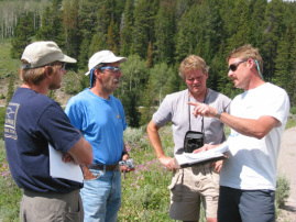
The Craighead Institute is partnering with the staff at Future West to help facilitate meetings with stakeholders and to integrate the stewardship tools into county planning and other land use decision making processes. Both Craighead and Future West have cultivated excellent personal and organizational relationships with governmental and nongovernmental partners through past field work. This includes direct and significant involvement in local watershed initiatives and landowner groups. We regularly hold workshops and meetings with a diverse group of stakeholders, including Montana Department of Fish, Wildlife and Parks; Idaho Fish and Game; U.S. Forest Service; Wildlife Conservation Society; Madison County Planning Department; Madison County Commission; RPI Consulting; Madison Valley Ranchlands Group; Moonlight Basin; and other developers and private citizens.
The Craighead Institute provides its stewardship planning tools to anyone who can use them, and helps to train people in their use. We are now extending this process to partners in Beaverhead County,Montana, and Fremont County, Idaho—neighboring regions that share the same wildlife and development concerns as Madison County. This larger focus is called the High Divide. There are currently several complementary initiatives in the High Divide.
In addition, we work with land trusts to provide maps and data generated by our research that identify critical, yet currently unprotected parcels. Thanks to community outreach by Future West, landowners holding such important parcels have become more interested in easements and other conservation measures. Such outreach is not only valuable, but essential for the long-term success of rural landscape conservation efforts.
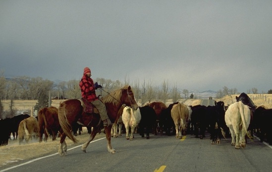
Maintaining ranching communities in harmony with wildlife is one of the goals.
