The Interior Cedar-Hemlock Forest of North America
Old-growth rainforests are among the most biologically rich and diverse ecosystems in the world. Coastal temperate rainforests are estimated to comprise only 2% of earth's ecosystems. In North America, the Inland Rainforest or Interior Cedar-Hemlock Forest is an even rarer type. Inland Rainforests occur in a small area in southeastern British Columbia and, to a lesser extent, northern Idaho, Washington and Montana.
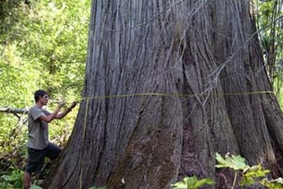
Located in North America's wettest inland mountain valleys, these forests are distinguished by a predominance of western red cedar, western hemlock, and many typically coastal species of lichens. Several old cedar trees have been documented to be over 2,000 years old. Old-growth stands provide critical habitat for several species at risk, including grizzly bears, woodland caribou, and bull trout. Woodland caribou are now extinct in Montana, endangered in Idaho, and classified as a "species at risk" in southern British Columbia. Bull trout are classified as threatened in the U.S and "at risk" in British Columbia. |
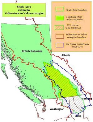
To identify the remaining areas of the Interior Cedar-Hemlock Forest that are priorities for conservation, the Craighead Environmental Research Institute has refined a method that focuses on mapping critical habitat for six focal species: grizzly bear, wolf, wolverine, lynx, cougar, and mountain caribou. Our basic assumption is that if we can maintain healthy populations of these six species we can protect biodiversity and healthy ecosystems. To do this we develop computer-based habitat suitability models for each of the six terrestrial focal species. Our results identify habitat concentration areas (cores) for each species that are then merged into composites of these areas that could satisfy needs for several species. We then use least-cost-path connectivity methods to identify probable movement corridors between core areas. Next we model priority aquatic habitat for salmon and for threatened fish species. To evaluate our results we compare them with other modeling approaches, conduct rigorous statistical and optimization analyses, and validate them on-the-ground through workshops and field surveys. During 2006 we will incorporate other existing conservation plan results with our focal species results to develop a comprehensive Conservation Area Design (CAD) encompassing both BC and US regions.
|
British Columbia Forests
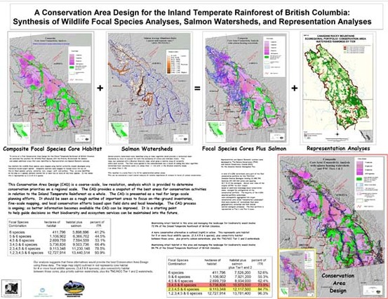
In 2004, in collaboration with the Valhalla Wilderness Society, we completed a broad-scale regional-level modeling approach for the Inland Cedar-Hemlock Forest (ICHF) of British Columbia, and identified 47.5 % of the region that we feel should be given a high degree of protection in order to ensure the persistence of our focal terrestrial and aquatic species for several hundred years. The initial results of the CAD process are broad-scale maps and generalized conservation guidelines over large areas. The subsequent results of the CAD process are fine-scale maps and site-specific conservation plans. This scale is most effective for a "bottom-up" approach where local residents and groups use the data to guide on-the-ground efforts to secure conservation easements, purchase land, provide input into land management planning processes and otherwise work to ensure that conservation priorities are met. The results, over a wide landscape, are solutions for pieces of the larger puzzle that are important to people at a local level. Copies of the CAD and related reports can be found at http://www.savespiritbear.org/. Additional technical details for the BC portion can be found at this link: Additional Technical Details: The Interior Cedar-Hemlock Forest of North America, BC portion)
In 2005 and 2006 we began to extend the broad-scale analysis across the border to include the Interior Cedar-Hemlock forests in Idaho, Montana, and Washington. In parallel with this we have begun to develop fine-scale designs of core areas and corridors for key regions of this study area using a higher-resolution habitat suitability modeling approach and least-cost-path methodology. After a field visit during June of 2005 we decided to focus our fine-scale modeling on 4 or 5 'corridors' around the 'core' area surrounding Wells Gray Provincial Park.
In 2005 and 2006 we began to extend the broad-scale analysis across the border to include the Interior Cedar-Hemlock forests in Idaho, Montana, and Washington. In parallel with this we have begun to develop fine-scale designs of core areas and corridors for key regions of this study area using a higher-resolution habitat suitability modeling approach and least-cost-path methodology. After a field visit during June of 2005 we decided to focus our fine-scale modeling on 4 or 5 'corridors' around the 'core' area surrounding Wells Gray Provincial Park.
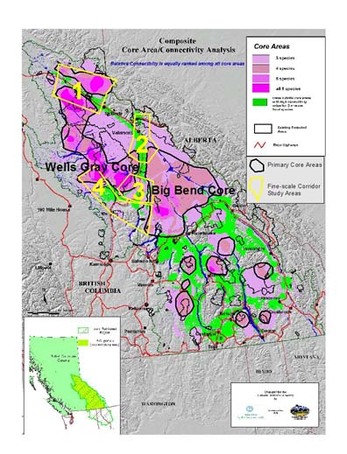
At the fine-scale we are focusing our initial analyses on connectivity with the two largest core areas: the area around Wells Gray Provincial Park (Wells Gray Core), and the area north of Revelstoke (Big Bend Core) in the areas outlined in black on the map. We will analyze connectivity and finer-scale core/secure areas 1] in the 'corridor' between McBride and Prince George; 2] the 'corridor' between both core areas and the Canadian Rockies around Mt Robson and Valemount, 3] the 'corridor' between the two core areas across the North Thompson River north of Clearwater, and 4] the 'corridor' between the two core areas south of Clearwater. The areas outlined in yellow on the map are general boundaries of these study areas.
Expected results will include fine-scale maps of core areas approximately 50 sq kilometers in size or larger, and optimum corridor habitat between them that connects the two large core areas with each other and with habitat in the Rockies to the north. These maps should help define the most critical areas to focus conservation efforts on.
Fine-scale analysis in BC has been delayed pending acquisition of the necessary data. There are two data sets needed: VRI (vegetation resources inventory) and FIP (forest inventory program) data. We hope to receive the data by the end of May 2006. We then hope to have some detailed connectivity maps completed by the time of our next field visit in early August 2006. We plan to work closely with BC conservationists and government biologists to ground-truth our models and increase their accuracy.
In BC the Valhalla Wilderness Society (VWS) and Save the Cedars League (STCL) have been using our results to guide conservation activities. STCL has used our maps to gain Old Growth Management Area status for many areas within the cores and corridors we identified. VWS has collaborated with First Nations in the area and at least one band, the Canim Lake Band, has been using our maps of core areas to identify areas they want in Treaty Negotiations with the BC government. Other groups, including the Headwaters Alliance and Forest Ethics have been using the maps indirectly in their decision-making.
Idaho, Montana, and Washington Forests
In 2005 we completed broad-scale mapping of core areas and corridors for the six focal species in the U.S. portion of the ICHF and began a refinement of the B.C. portion in order to complete a seamless, transboundary map. In collaboration with Dr. Justin Williams of Johns Hopkins we began an optimization analysis to determine the most efficient designation of core areas to meet thresholds for all focal species. We also began a corridor boundary/bottleneck analysis in collaboration with Dr. John DiBari with the US Forest Service Fire Science Lab in Missoula to better understand the possibilities of identifying wildlife movement habitat. Additional technical details for the US portion can be found at this link: Additional Technical Details: The Interior Cedar-Hemlock Forest of North America, US portion). The preliminary results indicate that key core habitats are found in the Selkirk Mountains, the Cabinet Mountains, and in the St. Joe National Forest as well as other areas.The use of spatial optimization programs indicates that this approach can be very effective and offers a more rigorous method for prioritizing habitat in British Columbia and the U.S. at both the broad and fine scales (regional and local). The optimized core solution will be displayed soon.
Transboundary Forests
By April 2006 we had refined the BC modeling to match the approach used for the US portion; and completed a seamless transboundary analysis of critical core areas and the optimal connectivity habitat between cores.
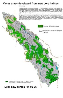
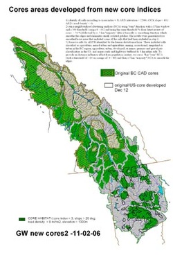
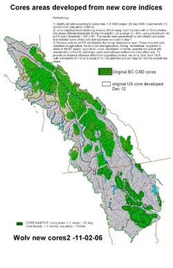
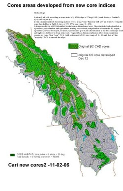
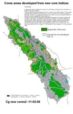
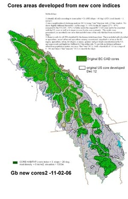
The resultant broad-scale maps identified the core wildlife habitat in the Inland Rainforest of North America with the highest conservation priority. We currently have fine resolution data for the US area and will begin fine-scale mapping for that region by the fall of 2006.
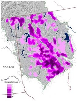
There are significant areas of core habitat in the Inland Rainforest for all of the six focal species (grizzly bear, wolf, wolverine, cougar, lynx, and caribou) on both sides of the US-Canada border, and varying degrees of connectivity between the cores.
Core areas for each of the focal species are shown below:
The resultant broad-scale maps identified the core wildlife habitat in the Inland Rainforest of North America with the highest conservation priority. We currently have fine resolution data for the US area and will begin fine-scale mapping for that region by the fall of 2006.
There are significant areas of core habitat in the Inland Rainforest for all of the six focal species (grizzly bear, wolf, wolverine, cougar, lynx, and caribou) on both sides of the US-Canada border, and varying degrees of connectivity between the cores.
Core areas for each of the focal species are shown below:
|
|
|
|