A long-term adaptation strategy for climate change
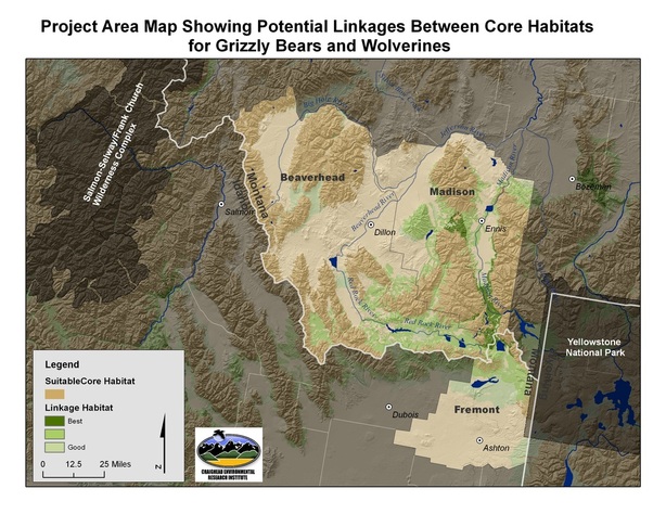
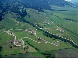
The High Divide region straddles Montana and Idaho and is home to numerous mountain ranges, valleys and rivers including the Madison and Jefferson Rivers; the Tobacco Root Mountains; and the Madison, Bighole and Centennial Valleys. Adjacent to the Greater Yellowstone Ecosystem (GYE), experts consider it one of the most intact biological areas in the lower 48 states, with abundant wildlife populations of elk, antelope, and deer. The region is also critically important for wolverine and grizzly bear recovery. It is not surprising that this scenic landscape and abundant wildlife have attracted many new residents to the area. This ongoing development, however, has led to an increase in road density, habitat fragmentation, and human-wildlife interaction. |
The Craighead Institute believes that development that respects wildlife habitat and corridors is possible. However, it must be founded in good science based on the best available data.
Planners, wildlife managers, and landowners need access to this information in an understandable and applicable format in order to make informed decisions about future development. The Craighead Institute’s project engages landowners, planners and government entities in a collaborative process to guide development, inform land-use decisions and improve land stewardship so that wildlife linkage routes are maintained in the High Divide region.
|
This project expands on our current land-use planning initiative in the Madison Valley which incorporates the most extensive and current data on wildlife conservation into subdivision regulations for the county. Using GIS-based tools developed by our staff, this framework provides fine-scale analyses at the parcel level, enabling decision-makers to determine areas that warrant unique mitigation, balancing development with wildlife corridor integrity, and it includes planning for transmission line locations. Based on success to date with local stakeholders and conservation partners, the next step is to expand this process to neighboring counties in the High Divide region. The Craighead Institute is laying the foundation for a development planning strategy which will preserve the qualities of the High Divide so critical to humans and wildlife.
|
 |
Collaboration
Craighead staff will collaborate closely with Future West to help with facilitating meetings and implementing the results into county planning processes. The approach outlined here will allow appropriate development of subdivisions, their supporting infrastructure, and accompanying commercial developments without forming barriers to wildlife movement. It will offer alternatives to minimize the negative impacts of rural subdivisions on the best wildlife areas, thus maintaining connectivity to a large complex of unfragmented wildlife habitat in the High Divide, and providing space for animals to respond to development pressures and climate change.
Craighead Institute - Building Tools for counties, developers, landowners and state agencies
The overall goal of this project is to maintain and enhance core habitats and wildlife connectivity for large carnivores and other species along the High Divide by:
- Improving detailed knowledge and information on key wildlife habitats, corridors and linkage areas.
- Identifying priority actions in the High Divide region that counties, developers, landowners and state agencies can take to better manage growth and land use practices in a manner that reduces impacts on habitats and habitat linkages and on the fiscal well-being of the counties.
- Assisting Madison, Beaverhead and Fremont counties in updating land use policies, subdivision regulations, development codes, and land trust priorities, and improving site specific development proposals to reflect recommended actions for mitigating the impacts of rural development on habitats and habitat linkages and on the counties’ fiscal well-being.
- Implementing a landowner landowner outreach strategy for assisting rural landowners in adopting wildlife stewardship practices including application of various stewardship and easement incentives.
