Conservation Planning for Wolf Creek
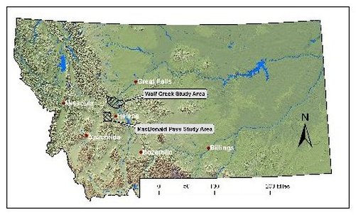
The Wolf Creek Corridor is located along Interstate 15 between Helena and Craig, Montana, in the Helena National Forest. This Study Area is within Lewis and Clark County and is located between roadless areas in the Big Belt Mountains and the Scapegoat Wilderness. The Missouri River flows through the study area.
Craighead Institute received a grant from The Liz Claiborne & Art Ortenberg Foundation in July 2005 for our project "Protecting Wildlife Corridors in the Northern Rockies" which we are doing in partnership with American Wildlands (AWL).
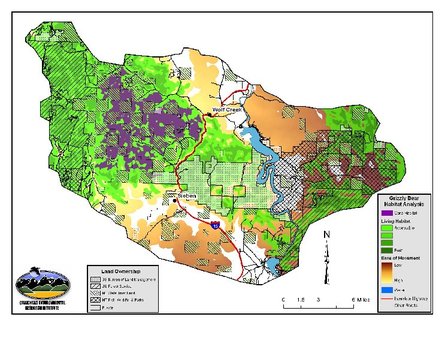
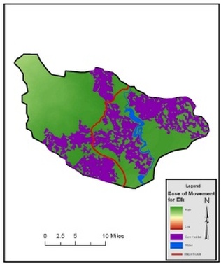
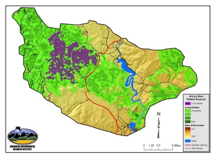
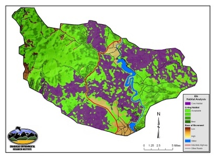
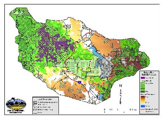
Although much of the study area is private land there are relatively few secondary roads. A large core of grizzly bear habitat is found on a mosaic of private land and State of Montana lands. This area also can support other forest carnivores and prey species. Core elk habitat is found on more open grassy areas with few roads. The best connectivity habitat for both species occurs between the Big Belt Mountains and the Scapegoat Wilderness crossing the Missouri between Upper Holter Lake and Holter Lake. Much of this corridor area is located on public lands: BLM, Forest Service, and State of Montana, and passes through the northern portion of the Sieben Ranch.Conservation priorities for the Wolf Creek Study Area will include: 1) working with BLM land managers to ensure that elk and grizzly habitat and connectivity is maintained through BLM lands in the center of the study area; 2) fostering further cooperation between Montana Fish Wildlife and Parks, the Montana Department of Natural Resources, the Sieben Ranch, and other private landowners to maintain grizzly core and living habitat through conservation easements and other mechanisms; and 3) working with the Helena National Forest to maintain wildlife habitat at the northwest and southeast edges of the study area. This area is probably more important as a movement corridor for bears and forest carnivores then as secure habitat for resident animals.
Using the analysis provided by CERI, AWL will begin conservation planning and outreach activities in the Wolf Creek area in 2007. Many of the agency and conservation organizations active in MacDonald Pass are aware of the Wolf Creek project and will take part in the Wolf Creek working group. This overlap will increase the efficiency of establishing the working group and identifying specific conservation actions for the conservation plan. Because of its location and more limited development there are greater opportunities for conservation in the Wolf Creek area. Connectivity for forest carnivore and big game movement is much greater than MacDonald Pass.
The objectives are to:> Develop model results in a GIS for a grizzly bear/carnivore and an elk/ungulate model for two key areas of connectivity in Montana that have been identified by our regional coarse-scale wildlife corridors model: MacDonald Pass west of Helena; and Interstate Highway 15 near Wolf Creek.
> Gather local existing data and field-truth the results of each model.
> Develop informal working groups for each corridor to use the results of the carnivore and ungulate analyses. These will consist of local stakeholders, federal and state agencies, transportation officials, NGO conservation groups, local land trusts, and interested individuals.
> Produce landscape-level conservation planning results prioritizing key parcels of land based on the results of the analyses, empirical data and ground-truthing. Each of the working groups will provide input and local knowledge to CERI and AWL to refine the final products.
> Recommend conservation priorities across a mosaic of private and public lands for each of the wildlife corridors. Each working group will work with other stakeholders to maintain and restore priority wildlife habitat.
Modeling and Mapping
The initial phase of these projects developed habitat suitability models for grizzly bear and elk at a resolution of 90 m2. In the subsequent phase of the projects we refined the models and translated them into ESRI Modelbuilder format. Habitat suitability models at a resolution of 30 m2 were developed for MacDonald Pass.
For the Wolf Creek Corridor we created a new landcover data set using orthophotos which were classified into traditional Montana GAP landcover classes at an even finer scale of resolution. Modeling of cores and corridors for Wolf Creek was subsequently completed by CERI during fall 2006. Results for Wolf Creek will be implemented during the winter of 2006.
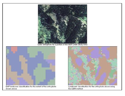
Habitat modeling of the Wolf Creek area was delayed due to accuracy issues with landcover from the Montana Gap Analysis Project (GAP) at the scale of our analysis. Although the GAP landcover data is generally quite good when working over very large areas at the scale it was developed for, accuracy becomes an issue when working on small areas such as the Wolf Creek and MacDonald Pass study areas. Therefore, Tom Olenicki at CERI developed a new, accurate, method using color aerial orthophotos to create an improved landcover data layer for the Wolf Creek study area.
The CERI landcover classification method uses a combination of remote sensing techniques for classifying satellite imagery and air photo interpretation.
This Figure provides an example of a color air photo for a portion of the Wolf Creek Study Area, the GAP landcover classification for the same area, and the CERI method of classification. The figure indicates how the CERI method is better able to classify landcover patterns at the scale it naturally occurs. Actual landcover classes are compatible with the GAP classes, allowing integration with all previous work we have done.
Results
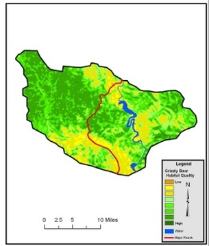
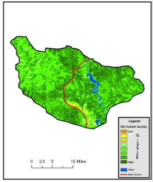
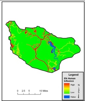
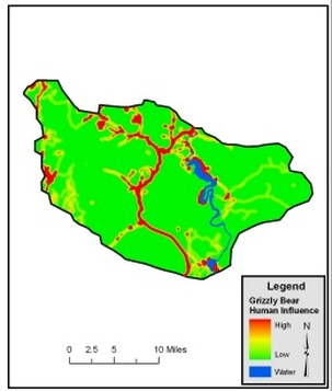
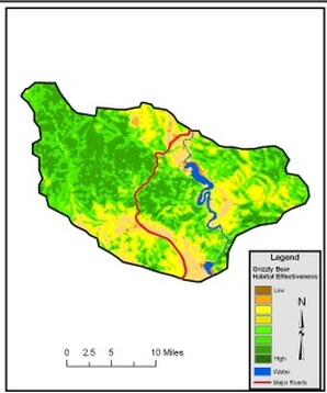
Habitat Quality for grizzly bears and elk are shown here. These maps are the first outputs of the modeling process for each species and indicate the quality of habitat across the entire study area without considering human influence. Human influence is modeled from a combination of a roads layer containing a weight for each road type based on the type and expected amount of traffic and a layer containing locations of structures.
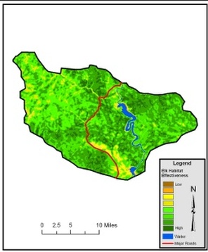
Modeled Human Influence (shown here) Grizzly Human InfluenceElk Human Influenceis then subtracted from Habitat Quality to indicate Habitat Effectiveness for each species.
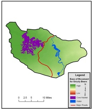
Our Habitat Effectiveness outputs are then used to define core areas for each species based on a minimum-sized area of contiguous habitat that is also above a minimum Habitat Effectiveness value. Core areas are shown in purple on the maps below.
Although selected species may not actually live in core areas for various reasons (e.g grizzly bears have been extirpated from much of their former range), the quality and amount of habitat in these areas is sufficiently high that they should be able to support the species.
Habitat Effectiveness is also used to create a cost surface for connectivity analysis between all core areas where higher movement costs are associated with lower quality habitat and lower costs are associated with higher quality habitat. Least-cost-path analysis (LCP) is then conducted to define the minimum cost value for movement amongst all cores within each study area and to the closest cores in all directions outside the study areas.
Cores outside the study areas for this analysis were defined from our previous coarse-scale analysis. Successful movement between core areas for animals is undoubtedly dependent on total cost and theoretically on stepping stones of sufficient habitat to provide visual stimulus and security for continual movement. Therefore, we conduct a process to select movement habitat that is both below a maximum movement cost and within a minimum distance of sufficient habitat. While core areas are intended to define areas large enough and of sufficient quality for an animal to spend its entire life (the best of the best), habitat of sufficient quality also exists outside these areas where they may make a living. We have defined these areas as "Living Habitat" based on their Habitat Effectiveness rating, location within movement corridors, and minimum size. The combination of Core Areas, Living Habitat, and Connectivity Habitat for grizzly bears and elk is shown here.
The mapping and analysis for the Wolf Creek Project has been completed with a higher degree of resolution and accuracy than was available for MacDonald Pass. This will facilitate the use of these maps at the section or even parcel level for conservation planning and decision-making. This approach will also be applicable to other areas of conservation interest across Montana. Using the analysis provided by CERI, AWL will begin conservation planning and outreach activities in the Wolf Creek area in 2007. Many of the agency and conservation organizations active in MacDonald Pass will take part in the Wolf Creek working group. This overlap will increase the efficiency of establishing the working group and identifying specific conservation actions for the conservation plan. Because of its location and more limited development there are greater opportunities for conservation in the Wolf Creek area.
